Road Scanning and Surveys

XenomatiX offers 6D Road Scanning Services to road authorities, engineers, inspectors, surveyors, and other stakeholders interested in providing road safety. XenomatiX uses the 6D road lidar to collect high-precision and up-to-date data on road networks or sections requested by the customer.
We gather raw digitized information about roads, encompassing details such as surface damages, surface conditions, and road markings. The data is collected using XenoTrack mounted on the vehicle. Any road can be digitized including community roads, national roads, highways, harbor quays, airport runways, and bike lanes.
Depending on the required usage of the data, different formats and further analyses are offered.
Request Data SampleReal Time Road Quality Indices
XenomatiX calculates on-board and in real-time International Roughness (IRI) and Rutting Index
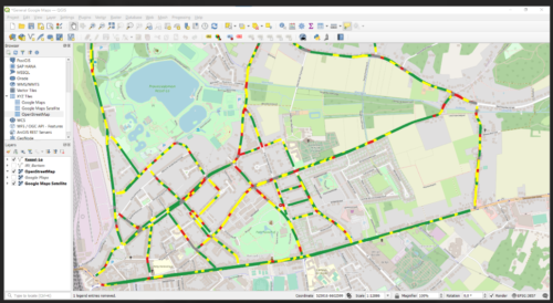
In real-time, the XenoTrack road lidar calculates the IRI, CE and Rutting quality index while performing the road survey data collection. Upon arrival home, the quality indices are readily available to upload to your GIS.
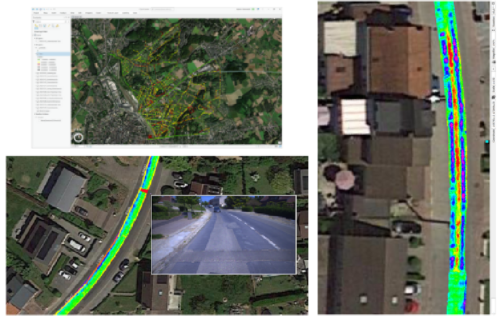
A GIS system is then used to combine and relate the information of 2D pictures, 3D geometric twin, road markings and quality indices, and show the quality analyses on a streetmap visualization
How easy is it to Collect Pavement Data?
It is very easy and quick to collect pavement data with XenoTrack, road lidar.
- XenoTrack is set up in only 45 mins on any vehicle
- XenoTrack comes in two versions, the single and dual lane. Dual lane measures up to two lanes simultaneously
- Once set up, only one driver needed to collect the data
- Even at high speeds data collection remains highly accurate
- Road quality indices (IRI, EC, Rutting, …) are calculated on board
- XenoTrack provides a georeferenced true digital representation of the road surface
- Data is quickly imported into any GIS system
- Road sections and cracks are analyzed to determine when and where repairs are needed
Find out which pavement type we measure – here
XenomatiX Road Data allows you to perform
- Road quality management (PMS)
- Planning for preventive and curative road maintenance
- Road obstructions check
- Road topography and mapping
- Reference data for camera technology
- Proving ground profiles management
- Digital twin of road assets (BIM)
- Research and simulations using road profiles

Post-processing and analyses
- International roughness index (IRI)
- Longitudinal evenness
- Transversal evenness
- Rutting index – left & right
- Road markings – Available On-Demand
- Cracks – Available On-demand
- Potholes – Available On-demand
- Subsidence – Available On-demand

The XenoTrack system aligns perfectly with our commitment to excellence in road maintenance. We believe this collaboration will set new standards in our industry and benefit our clients by enhancing the quality of data that will flow into our Streetlogix Asset Management platform for advanced decision-making purposes
XenomatiX allowed us to visualize the IRI on a Google map and classify roads and tracks fast and easy with a very good correlation to the subjective findings of our certified drivers.
XenomatiX’ road data convinced logistics companies in the Antwerp harbor of the power of LiDAR in continuous quay quality management, with the perspective to deploy an autonomous health and safety system for their manpower.
The R&D partnership between BRRC and XenomatiX focuses on affordable solutions for smaller road network owners that aim for performant and cost-effective road management. We also focus on exploring the tight link between road data infrastructure to autonomous vehicles of the near future.
We receive data for every cm² of Leuven’s streets. The data is visualized on a GIS system and colour coded, this instantly enables our team to assess the exact condition of the road surface. Additionally to the 3D map, XenomatiX provides 2D images of the road surface, so that no road distress remains unnoticed
‘’XenomatiX’ systematic approach has provided us with clear and actionable insights into the condition of our roads. We appreciate the simplicity and effectiveness of their system.’’
